Instruction
1.Setup Garmin GPS Protocol
Choose GRMN/GRMN, HOST for data transfer or map-based navigation.
Choose NMEA mode only when you specifically want to do NMEA Navigation
(for example, this allows the use of a non-Garmin GPS receiver
that supports NMEA out.
2.Install
Copy garmapce.exe to appropriate folder, and copy mfcwce.dll to the \Windows folder or "Storage Card" folder.
3.How to create a map data.
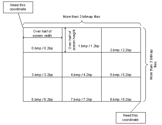
Garmap CE needs at least 9 (means 3 * 3) bitmap files for map data. Each file is named 0.bmp (or .2bp), 1.bmp, etc. from upper-left to lower-right, and a information file to calibrate coordinate too. There is no upper limit on the number of bitmap files and size other than the memory size. Garmap CE needs devided bitmap files because it supports large map areas. Garmap CE loads 9 bitmap files at a time, and loads other files as nessesary.
If you have more than one map region, each map data has to
be stored a separate directory.
Format of an information file (mapinfo.dat)
------------------------------------------------------------------------
| line 1 | Garmap CE | ; program name (fixed string) |
| line 2 | 101 | ; version of map data |
| line 3 | 2bp | ; bmp or 2bp (depends on bitmap format) |
| line 4 | 3 | ; number of horizontal bitmap files (more than 3) |
| line 5 | 4 | ; number of vertical bitmap files (more than 3) |
| line 6 | 47.8525 | ; latitude of upper left (degree) |
| line 7 | 10.0825 | ; longitude of upper left (degree) |
| line 8 | 47.2975 | ; latitude of lower right (degree) |
| line 9 | 11.31722222 | ; longitude of lower right (degree) |
| line 10 | 288 | ; width of 1 bitmap file (pixel) |
| line 11 | 144 | ; height of 1 bitmap file (pixel) |
| line 12 | 8 | ; color depth of bitmap file(independence from actual color depth) |
------------------------------------------------------------------------
4.How to calibrate a map data.
Sometime we want to create/re-create mapinfo.dat using the points which knows
coordinates.
To realize this, Garmap CE uses 2 different points.
How to operate.
You decide two points which coordinates are known and separated to the diagonal as much as possible.
Load map which has 2 points you decide.
Tap the first point with SHIFT and CONTROL key. "Calibrate Map"
dialog will appear. You input the coordinates value in P1. Then, input the
coordinates value of the 2nd point in P2.
Mapinfo.dat will be re-created, and map data will be loaded automatically.
5.Multi Map
Garmap CE has a feature called Multilple Map Support.
Sometimes we want to change a map scale simply. Garmap CE comes
up to this requirement.
For example, a directory for maps are composed as follow.
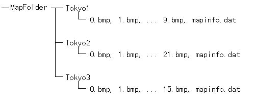
If you make a list file of maps, you can change maps rapidly.
A list files include following informations.
---------------------------------
Map List for Garmap CE
101
Tokyo1\mapinfo.dat
Tokyo2\mapinfo.dat
Tokyo3\mapinfo.dat
---------------------------------
First 2 lines are fixed.
Each map should have a different scale.
A list file has to be stored in "MapFolder".
Please explore the features of Garmap CE.
Copyright(C) 1997-2001 Fukuro.