2012/09/22
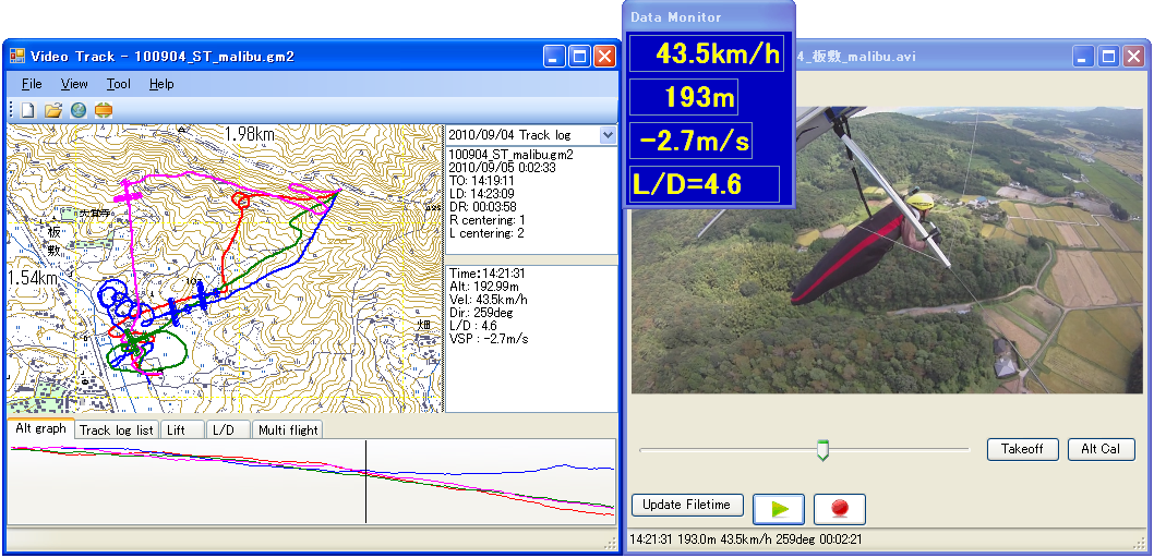
VideoTrack displays tracks from GPS in synchronization with the corresponding video.
This program requires Microsoft .NET framework 3.5 or newer.
VideoTrack DOWNLOAD
sample data(log, map, video)
Version 6.2.0 (2006/07/01)
GarComm.ocx is Active X control to communicate with Garmin GPS by Garmin protocol.
This will be shareware in future. Evaluation version is free to use.
| VideoTrack 2012/09/22 |
VideoTrack displays tracks from GPS in synchronization with the corresponding video. This program requires Microsoft .NET framework 3.5 or newer. |
Common Library DOWNLOAD VideoTrack DOWNLOAD sample data(log, map, video) |
| SkyTraqComm 2010/03/28 |
SkyTraqApp SkyTraqApp is a program to communicat with GT-730FL-S GPS DATA LOGGER DONGLE. [Feature] Download track log from GT-730FL-S. Load Garmap CE format map data. Load/Save Garmap2 format (.gm2) and IGC format data. [Notes] (1) SkyTraqApp requires LIBPNG(1.2.37) and ZLIB(1.2.3) dynamic link library. These files can be downloaded from GnuWin32 : http://gnuwin32.sourceforge.net/ Packages : http://gnuwin32.sourceforge.net/packages.html LIBPNG : http://gnuwin32.sourceforge.net/packages/libpng.htm ZLIB : http://gnuwin32.sourceforge.net/packages/zlib.htm or copy libpng12.dll and zlib1.dll from SkyTraqApp100.zip to [ProgramFIles]\fukuro\Common folder. (2) This program is tested only for GT-730FL-S. For the other series devices, this may not work properly. |
SkyTraqApp 1.0.0 DOWNLOAD |
|
Garmap CE source code 2002/04/17 |
eMbedded Visual C++ 3.0 英語版のプロジェクトです。
This is the project for English eMbedded Visual C++ 3.0. |
This version the latest version before supporting PNG format. |
|
PNGファイルを扱うために、ZLIBとLIBPNGを使っています。これらを使うためには、別途DLLを手に入れてください。 To use this version, you need ZLIB and LIBPNG library. |
|
Garmap PA Version 0.20 This program needs Japanese Map Program "ProAtlas". |
Garmap PAはプロアトラス2001/2002を地図データとして利用するGarmapみたいなプログラムです。 何ができるかというと、
といったところです。 何分、手持ちのプロアトラスでしか試せないので、複数の地域をインストールしていたりした場合の挙動テストはできていませんので、いろいろな環境で正しく動くかどうかは保証の限りではありませんが。 Garmap PAを実行させるためには、アルプス社のプロアトラス2001またはプロアトラス2002がインストールさせていなければなりません。 バージョン0.20ではプロアトラスのライセンスファイルは不要です。Niftyに入っていない方でも使えるようになりました。 |
|